Preliminary Reports Show 8 Tornadoes Touched Down In Central OK
<p>Periods of rain and storms will continue ahead of a cold front that will arrive Tuesday. </p>Tuesday, October 9th 2018, 7:49 am
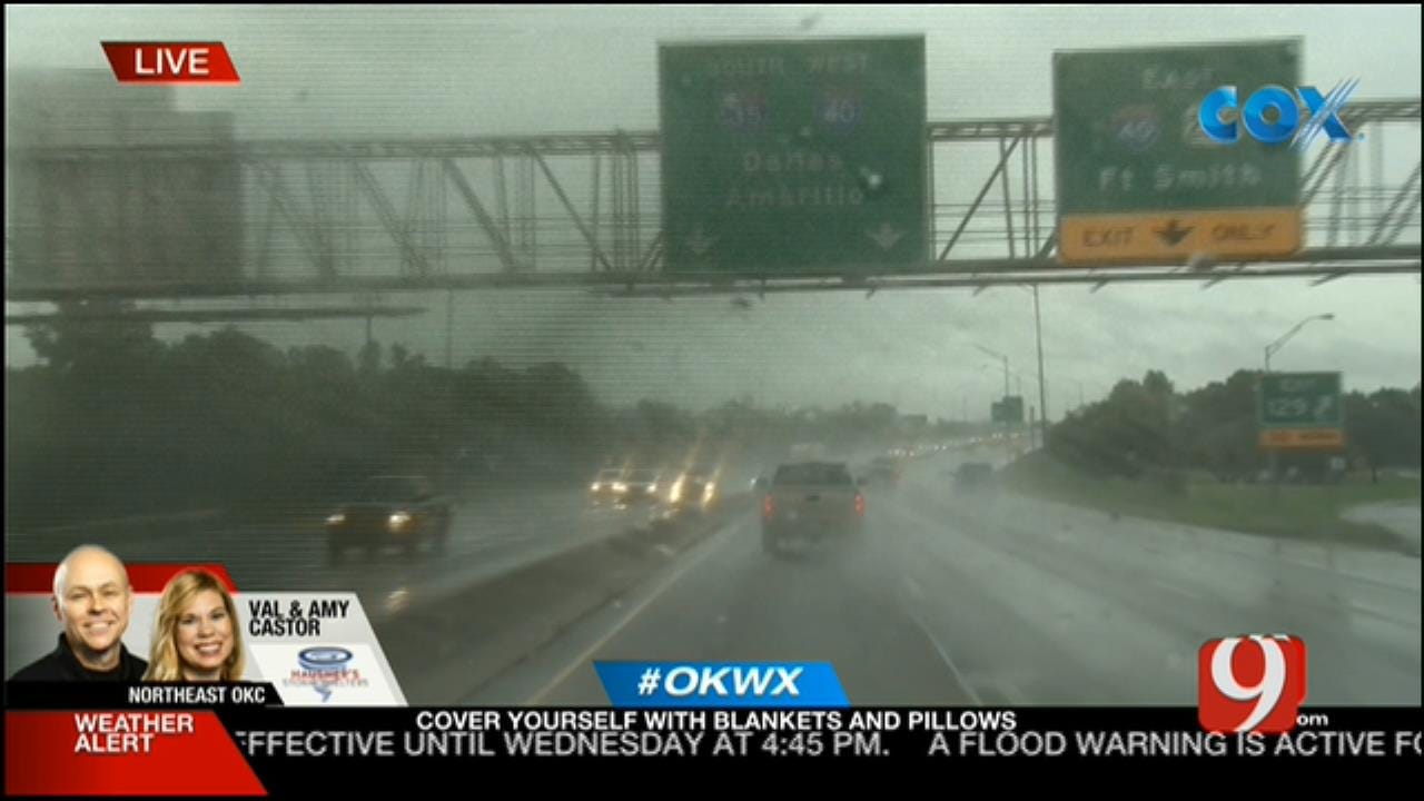
Tuesday's morning commute was interrupted by multiple tornado warnings in the eastern parts of the metro.
The tornado-warned storms cropped up along the line as it made its way northeast through the metro from as south as Lake Thunderbird in Cleveland County and as north as eastern Edmond.
One area of spin-up was spotted near Lake Thunderbird in Cleveland County, and the other was spotted by News 9 StormTrackers Val and Amy Castor near Interstates 44 and 35.
SHEAR SWATH: A line of storm formed this morning and small circulations formed within that line. The yellow line shows each path of the swaths of shear. Most occasionally produced brief and small tornadoes. pic.twitter.com/XK7hXa2mCj
— Jed Castles News 9 (@JedCastles) October 9, 2018
Preliminary tornado reports from this morning. Looks like an early 8 count. That number likely will change as damage is reported and surveyed. #okwx @NEWS9 pic.twitter.com/oYUyPaAWob
— Matt Mahler (@themahler) October 9, 2018
In Midwest City, several cars were found overturned and a roof was torn off after the heavy line of storms made its way through the area.
Wow! Look at this damage left behind here from these storms. Fire crews on scene tell us they are sending pictures to meteorologists in the area to get confirmed what rolled through this parking lot. This is JCPenney near the air force base. @NEWS9 pic.twitter.com/Rt31Jn020y
— Ashley Holden News 9 (@ashleyvholden) October 9, 2018
Damage near the Midwest city welcome center pic.twitter.com/P96HwBY0jr
— Grant Hermes News 9 (@GrantHermesKWTV) October 9, 2018
High winds also caused damage in southwest Oklahoma City when a firefighters had to remove a trampoline from a power line in the 2400 block of SW 81 Street.
A trampoline is in power lines and a concrete block wall was knocked down in the 2400 block of SW. 81st as high winds moved through the area. Rescue Ladder 9 is on scene now. No injuries reported. BF 8:50 a.m. pic.twitter.com/mrANUPJxOh
— Oklahoma City Fire (@OKCFD) October 9, 2018
Several parts of the metro lost power due to the strong storms. At a motel in northeast Oklahoma City near Frontier City, two people had to be rescued from an elevator after the power went out, according to News 9 reporter Chris Gilmore.
The area around Frontier City sustained damage after a tornado-warned storm passed the area.
The Oklahoma City Zoo was closed due to a power outage and some minor tree damage. They said they will reassess at noon to determine if they will open later in the day.
Even MORE damage from a possible tornado just southeast of Lake Stanley Draper southeast of OKC in northeastern Cleveland county. Another small swath of tree and house damage. #okwx @NEWS9 pic.twitter.com/mfKijdoJ0o
— Matt Mahler (@themahler) October 9, 2018
***
Periods of rain and storms will continue ahead of a cold front that will arrive Tuesday.
CHILLY NIGHT AHEAD: Flooding is the big concern today. Tonight we all clear out and temps will drop like a rock. Could see frost in the panhandle and NW OK. #okwx @NEWS9 pic.twitter.com/Ut3UbrUuYR
— Lacey Swope (@LaceySwope) October 9, 2018
Some severe weather and flooding will continue into the afternoon Wednesday.
HEAVY RAIN and increasing flooding concerns as your head out the door this morning. The latest timing and totals on News9. #okwx @NEWS9 pic.twitter.com/aCjFzfkVuS
— Lacey Swope (@LaceySwope) October 9, 2018
All modes of severe weather will be possible Wednesday afternoon.
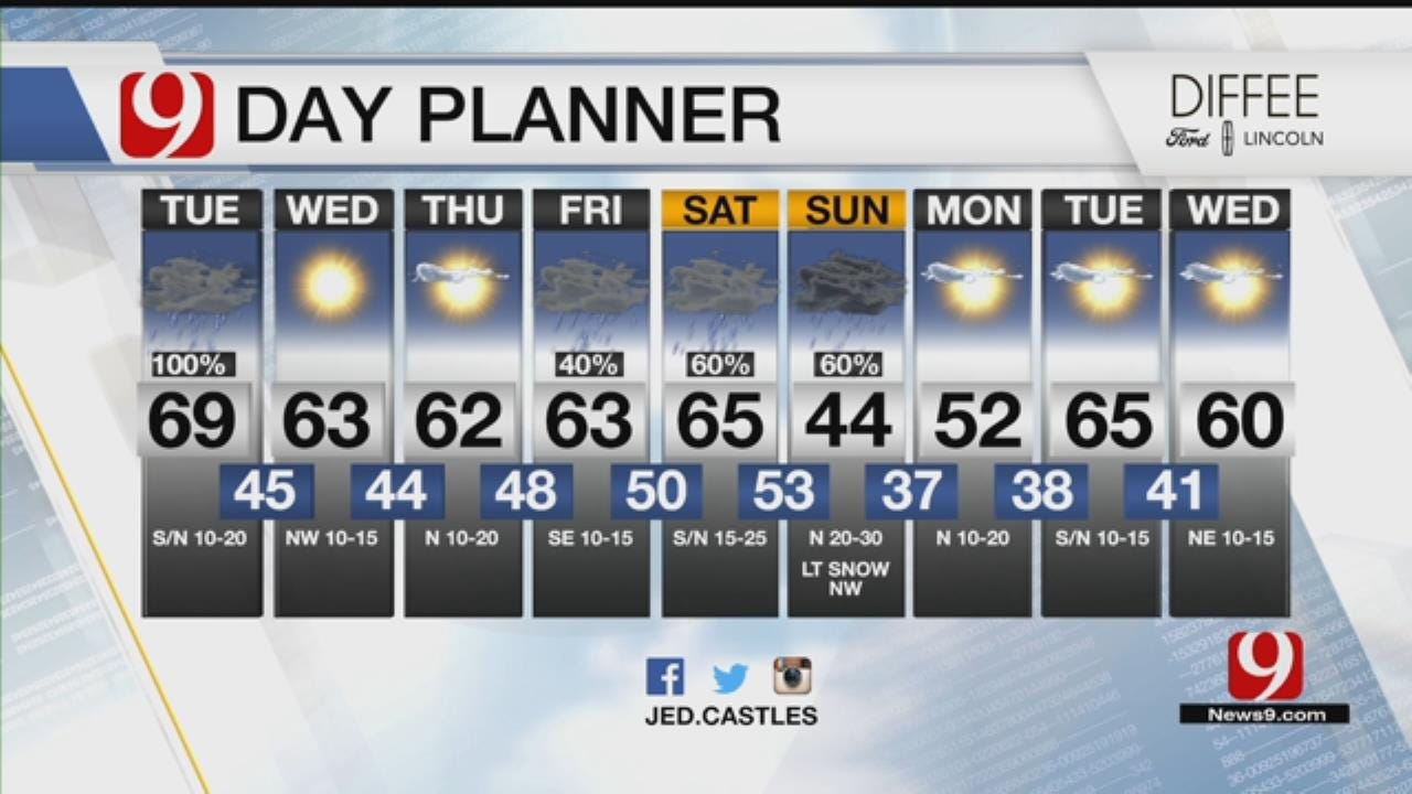
The fall pattern sets up with 40s and 50s for lows and highs in the 60s and 70s.
9 DAY: FALL TIME RETURNS TO OKLAHOMA! You can officially grab your favorite spiced coffee drink! Rain likely thru the day. Flooding and a few severe storms possible. Much cooler starting tomorrow. Weekend rain could change to snow NW on Sunday. 30's for lows Monday!@news9 #okwx pic.twitter.com/bWshkilkBK
— Jed Castles News 9 (@JedCastles) October 9, 2018
A pacific tropical storm will move overhead starting Friday. This will bring heavy rain back to the state on Saturday.
A stronger front pushes in late weekend. Lows in the 30s will spread in the state for the coldest air of the season. Some frost looks possible. That would be good news to start nipping the ragweed!
","published":"2018-10-09T12:49:11.000Z","updated":"2018-10-09T17:48:19.000Z","summary":"Periods of rain and storms will continue ahead of a cold front that will arrive Tuesday.
","affiliate":{"_id":"5cc353fe1c9d440000d3b70f","callSign":"kwtv","origin":"https://www.news9.com"},"contentClass":"weather","createdAt":"2020-01-31T17:02:20.029Z","updatedAt":"2022-03-30T20:04:08.497Z","__v":3,"breakingNews":[],"entities":[{"_id":"623909636880e45323e5a7ca","text":"Amy Castor","type":"PERSON","__v":0},{"_id":"62421a036880e45323a18787","text":"Matt Mahler","type":"PERSON","__v":0},{"_id":"623ddb4b6880e45323fb05c3","text":"Lacey Swope","type":"PERSON","__v":0},{"_id":"623a92826880e45323ea182f","text":"Lake Thunderbird","type":"LOCATION","__v":0},{"_id":"6241a79f6880e4532354829b","text":"Cleveland County","type":"LOCATION","__v":0},{"_id":"624219f56880e45323a167fe","text":"Midwest City","type":"LOCATION","__v":0},{"_id":"62421ba96880e45323a49c9b","text":"Frontier City","type":"LOCATION","__v":0},{"_id":"62421a5d6880e45323a2171d","text":"Lake Stanley Draper","type":"LOCATION","__v":0},{"_id":"62421e296880e45323a906e4","text":"OKLAHOMA","type":"LOCATION","__v":0}],"hasBeenCheckedForEntities":true,"openInNewWindow":false,"show":true,"link":"/story/5e345d9c3196993fcfd053ef/preliminary-reports-show-8-tornadoes-touched-down-in-central-ok","hasSchedule":false,"id":"5e345d9c3196993fcfd053ef"};More Like This
October 9th, 2018
January 16th, 2020
March 29th, 2019
November 13th, 2018
Top Headlines
March 13th, 2025


