Severe Storms Move Out Of Green Country
Severe weather threats return to Green Country on Thursday.Thursday, March 16th 2023, 1:54 pm


TULSA, Okla. -
Storms moved out of Green Country and cold air took its place Thursday night.
A Tornado Watch was issued earlier in the day and expired around 8 p.m.

Here are the details from News On 6 Meteorologist Stephen Nehrenz:
Another cold front moving through Green Country with chillier air and storm chances as we head into Thursday evening.
Strong south winds continued through the morning and midday hours, feeding moisture back across Oklahoma. Some widely scattered showers are possible through the morning with warmer morning temperatures than we’ve had recently. Most areas will be back into the lower to mid-60s by the early afternoon hours, which is when we’ll reach our high of the day in the Tulsa metro.
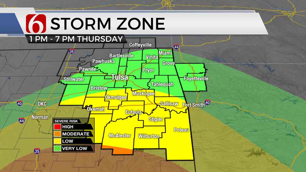
Our next strong cold front will enter areas northwest of Tulsa by early afternoon, reaching Tulsa by mid-afternoon. Once the front enters your area, the warm-up will end with temperatures dropping pretty quickly into the lower 50s and upper 40s. The main window for a strong to severe storm in the Tulsa metro and along the I-44 corridor will be right along that cold front in the early afternoon hours.

But across southeastern Oklahoma, the chance for storms and some severe weather is a bit higher. As instability and wind shear build ahead of the front, scattered strong to severe storms look to develop closer to and south of I-40. The main time window for this looks to be from about 3 PM to 7 PM. Large hail, damaging winds, and an isolated tornado would all be possible with storms across southeastern Oklahoma, so please remain weather aware!
Those storm chances look to quickly exit southeastern Oklahoma after sunset as the cold front races south and strong north winds return. A trailing band of precipitation well behind the cold front will move near the Oklahoma/Kansas state line during the night, and this could briefly turn over to a wintry mix in some areas. But no accumulation or impacts are expected.

Skies will clear out for St. Patrick’s Day Friday, but it’ll be a chilly holiday! Highs will hold in the upper 40s to around 50 on Friday with a blustery north wind. And for you gardeners out there, a heads up: More morning freezes are on the way both Saturday morning and Sunday morning, with a likelihood of hard freezes near and north of Tulsa.
I hope you have a great Thursday, Green Country! can follow me on Twitter @StephenNehrenz as well as my Facebook page to stay up to date with the very latest.

Get The Daily Update!
Be among the first to get breaking news, weather, and general news updates from News 9 delivered right to your inbox!
More Like This
March 16th, 2023

September 28th, 2024

September 28th, 2024

September 28th, 2024
Top Headlines

September 28th, 2024

September 28th, 2024

September 28th, 2024