Winter Storm Approaches Oklahoma With Snowfall Likely Across Parts Of The State
Oklahoma Weather Forecast: Bookmark this page and refresh it often for the latest forecast and daily updates.Wednesday, January 8th 2025, 7:44 am
TULSA, Okla. -
A Winter Storm Remains In The Forecast
Temperatures will remain in the lower 30s on Wednesday with light winds and mostly sunny conditions.
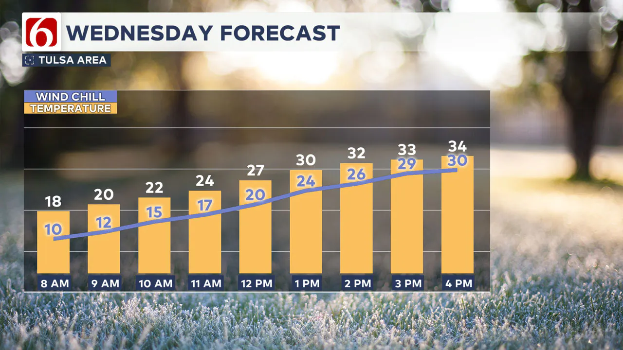
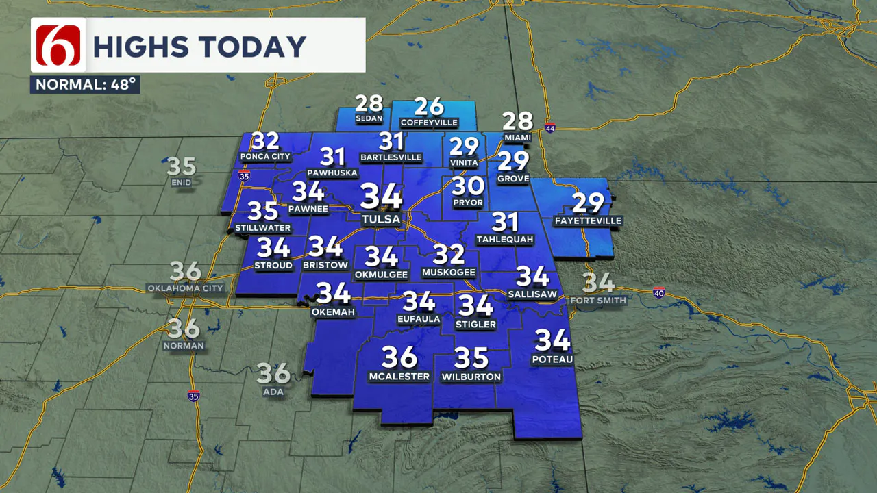
Highs on Thursday will reach the mid-30s before a strong winter storm approaches the state, bringing some snowfall to parts of the state.
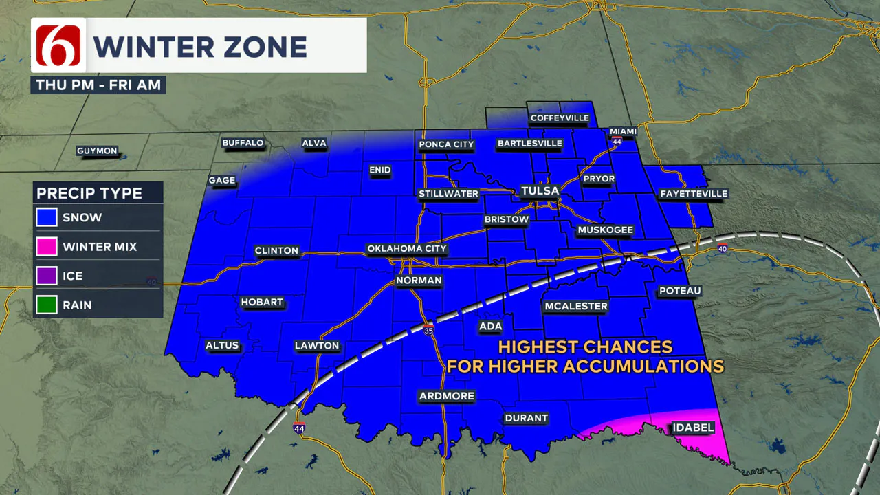
Winter storm watches remain in effect along and south of the I-40 corridor, extending into northern Texas and southwestern Arkansas for Thursday. The watch currently does not include the Tulsa metro area, but some snow is still possible across the metro and parts of northeastern Oklahoma.
>>> Frigid Weather Sparks Frostbite Warnings: What You Need To Know
Any Changes With The Storm Track?
The main upper-level system continues to move south early this morning across the southwestern states and will begin moving east this afternoon. Another wave in the northern stream is moving southeast and will merge with the southern stream system, bringing the potential for wintry weather to parts of the state.
There is still considerable uncertainty this morning regarding the exact track of this storm system. Some data from yesterday indicated the northern wave would arrive slightly faster than the lift from the southern stream, bringing lower moisture content to the atmosphere across parts of northeastern Oklahoma.
This morning’s suite of data, including some important ensemble data runs, has trended to a better chance of snow than the brief downturn in the data yesterday, which suggested drier mid-level air.
Latest Data Trends
Some operational data, including the last run of the EURO model, supports the mention of some banding of snow that may occur to the northwest of the main precip shield expected across the southeastern quadrant of the state. Predictability for any localized banding is extremely low in these events, but it is likely for a few spots.
Right now, this could occur in a few locations to the northwest of the Tulsa metro, mostly across northwestern Oklahoma into south-central Kansas based on these latest runs.
How Will the Storm Affect Snowfall Amounts?
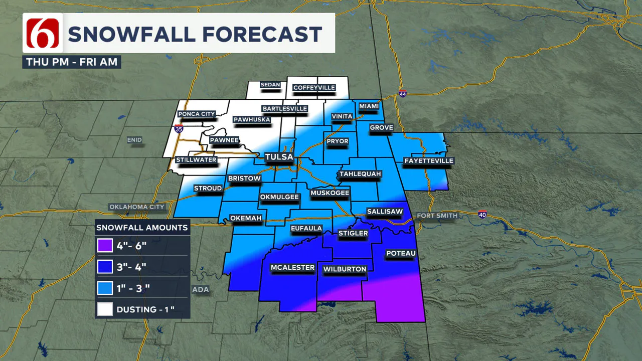
This creates differences in the snowfall amounts for the northeastern Oklahoma region along both sides of I-44. The more favorable location for significant snowfall remains across parts of southeastern Oklahoma into western Arkansas.
Amounts have trended lower compared to yesterday morning’s output regarding southeastern Oklahoma but would still produce amounts from 3 to 6 inches, with higher amounts in southwestern Arkansas.
Wintry weather is still likely across parts of northern Texas, including the Dallas-Fort Worth metro area, but the precipitation type may include a mixture of freezing rain to sleet and snow, which may lower totals compared to previous forecasts.
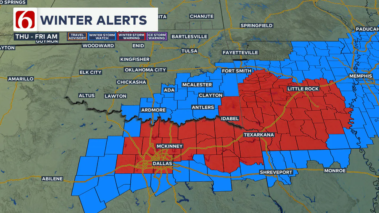
The latest data this morning indicates slightly warmer air during the initial onset of precipitation, which may also produce some pockets of sleet or even light freezing rain across the Red River Valley before transitioning to all snow by tomorrow afternoon.
As of this morning, we anticipate winter storm criteria for southeastern Oklahoma, with winter weather advisory criteria more likely across parts of northeastern Oklahoma.
Probability of Snow
Snowfall probabilities for the Tulsa metro area include an 80% chance of at least 1 inch of snow. The probability of 2 inches of snow is currently at 50%, and the possibility of 4 inches or more of snow is near or less than 10%.
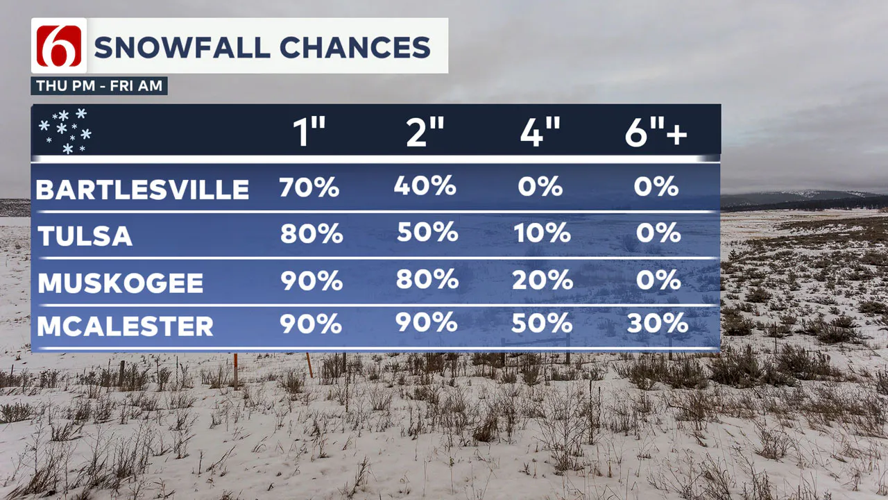
A higher probability for more significant wintry accumulation is currently forecast for the southeastern sections of our region.
Snowfall probabilities for McAlester support a 90% probability of 2 inches of snow, a probability of 4 inches near 50%, and a probability of 6 inches near or less than 30%.
>>> ODOT Shares Winter Travel Tips For Safer Driving In Snow And Ice
>>> How To Prepare Your Car For Oklahoma Winter Weather
Will Another Storm Affect the Area This Weekend?
Another upper-level wave will move across the state on Sunday. Operational data suggest a dry passage. Some ensemble data suggest a low-end chance for some light showers Sunday morning across far eastern Oklahoma. This probability remains near or less than a certain percentage.
Temperatures this weekend will slowly moderate. Morning lows will stay in the mid to upper 20s, with Saturday highs in the upper 30s and Sunday reaching the lower 40s.
Where are the warming shelters available in Tulsa this year?
The city of Tulsa, local shelters, warming stations, and outreach teams are working to ensure access to safe, warm spaces during the cold temperatures.
>>> Warming Shelters Open Across Tulsa Amid Freezing Temperatures
Tulsa shelters and temporary warming locations are open to provide refuge. Major locations include:
- John 3:16 Mission, 506 N. Cheyenne — Open 24/7
- The Salvation Army Center of Hope, 102 N. Denver Ave. — Open 24/7
- Tulsa Day Center, 415 W. Archer St. — Open 24/7
Temporary overflow shelters will also be open for the cold weather:
- Tulsa Dream Center, 4122 W. 55th Pl. — Opens Sunday, Jan. 5, at 3 p.m. and closes Tuesday, Jan. 7, at 9 a.m.; Adults only, pet-friendly.
- Rose Bowl, 7419 E. 11th St. — Opens Sunday, Jan. 5, at 2 p.m. and closes Thursday, Jan. 9, at 9 a.m.; Adults only.
For a full list of warming station locations and hours, visit Housing Solutions’ Winter Weather Information Page.
>>> Warming Shelters, Safety Tips For Cold Temperatures This Winter In Oklahoma
Bring Pets Inside!
Winter temperatures can pose additional challenges for pets, particularly older animals or those with health conditions. Hartfield recommends:
- Wellness Checks: Ensure pets are up to date on vaccines and discuss arthritis or other cold-weather health concerns with a veterinarian.
- Outdoor Time: Monitor the duration of outdoor activities, especially for short-haired breeds or pets with conditions like diabetes or heart disease.
- Paw Care: After walks, inspect and clean paws to remove ice or de-icing chemicals that could harm your pet.
>>> Cold Weather Pet Tips: How To Keep Animals Safe During Winter Months
How Can I Protect Myself From Sickness This Winter?
The Tulsa Health Department is urging residents to receive flu and COVID-19 vaccinations to prevent respiratory illnesses as Oklahoma enters the coldest months of the year.
- Health experts say the risk of respiratory illnesses is higher during the winter, as colder weather often leads to more indoor gatherings, increasing the likelihood of viruses spreading.
- The Centers for Disease Control and Prevention says Oklahoma is one of 11 states with very high respiratory virus activity, and with flu vaccination rates lower than this time in 2024, more people have reported getting sick.
>>> How to Protect Yourself From Respiratory Illness This Winter
Emergency Info: Outages Across Oklahoma:
Northeast Oklahoma has various power companies and electric cooperatives, many of which have overlapping areas of coverage. Below is a link to various outage maps.
>>> Tulsa HVAC, Plumbing Companies Flooded With Calls During Cold Weather
- PSO Outage Map
- OG&E Outage Map
- VVEC Outage Map
- Indian Electric Cooperative (IEC) Outage Map
- Oklahoma Association of Electric Cooperatives Outage Map — (Note Several Smaller Co-ops Included)
The Alan Crone morning weather podcast link from Spotify:
https://open.spotify.com/episode/26Z3drB6WgUBx4T94u8PKt
The Alan Crone morning weather podcast link from Apple:
Follow the News On 6 Meteorologists on Facebook!
- Meteorologist Travis Meyer
- Meteorologist Stacia Knight
- Meteorologist Alan Crone
- Meteorologist Stephen Nehrenz
- Meteorologist Aaron Reeves
- Meteorologist Megan Gold

More Like This
January 8th, 2025
January 8th, 2025
Top Headlines
January 8th, 2025
January 8th, 2025
January 8th, 2025


