

Winter Storm Brings Frigid Temperatures, Slick Roads, And Wind Chills In Single Digits
Oklahoma Weather Forecast: Bookmark this page and refresh it often for the latest forecast and daily updates.Sunday, January 5th 2025, 5:18 pm


TULSA, Okla. -
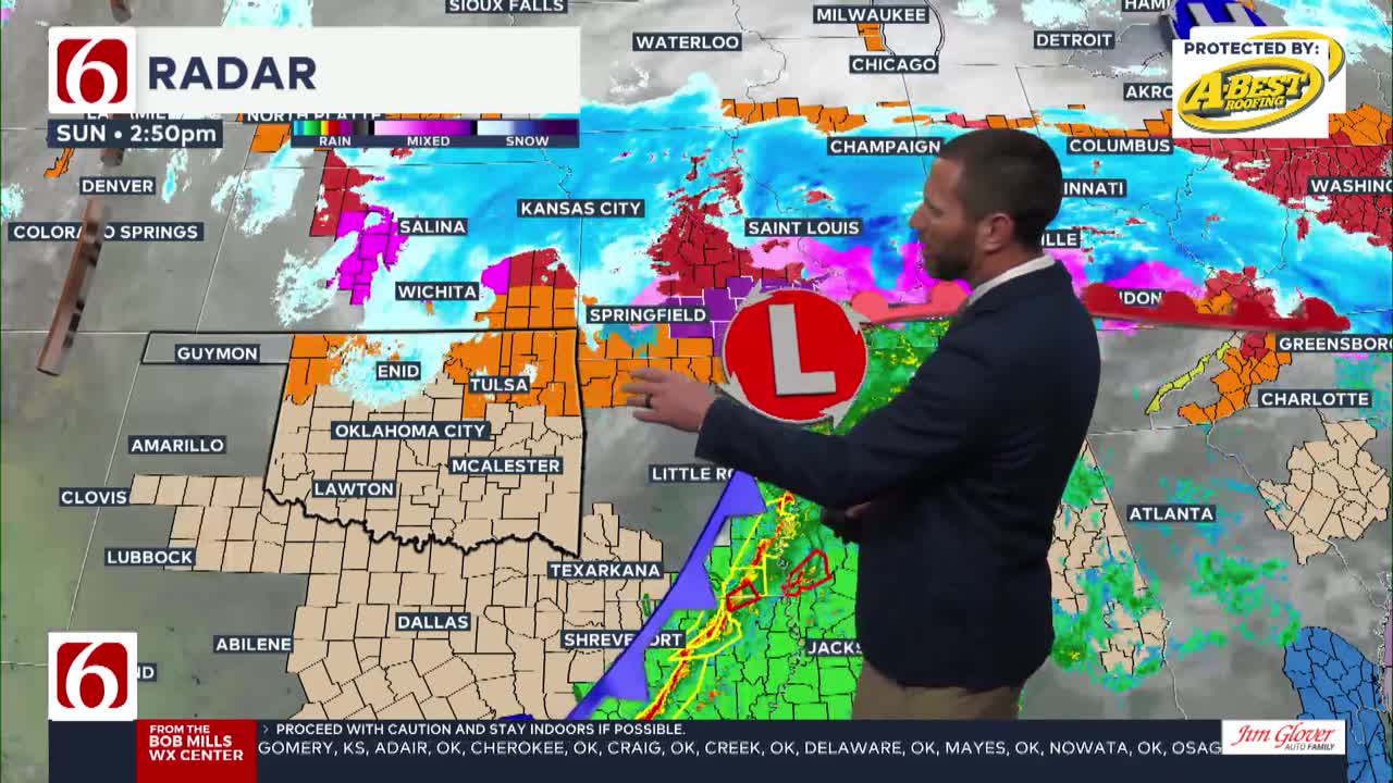
UPDATE 2 P.M. - The Arctic surge continues to take hold across Green Country. Winds are gusting 30-40 mph at times as temperatures continue to fall.

As a powerful winter storm system impacts Oklahoma and surrounding states, Oklahomans should prepare for freezing temperatures, dangerous wind chills, and slick roads.
Meteorologist Megan Gold outlines the timeline, weather conditions, and travel precautions Sunday morning.
What to Expect in Tulsa
Sunday Timeline:
- Morning: Temperatures in the 40s with damp pavement from showers and drizzle.
- Afternoon: Cold front drops temperatures to the 20s; wind chills fall to the teens and single digits.
- Evening: Snow flurries and blowing snow for areas north of Tulsa, with roads becoming slick.
Road Conditions:
- Road temperatures behind the front are in the teens, leading to icy and snow-covered surfaces in northern and western areas.
- Elevated surfaces like bridges and overpasses are especially hazardous.
>>>ODOT Shares Winter Travel Tips For Safer Driving In Snow And Ice
Key Areas with Risky Roads:
- Travel Precautions: Avoid travel to the north and northwest where conditions are dangerous due to ice and snow.
- Bartlesville to Coffeyville
- Pawhuska and surrounding areas
- If travel is necessary, drive slowly and plan extra time to reach your destination.
>>>How To Prepare Your Car For Oklahoma Winter Weather
---
A major winter storm will impact the Southern and Central Plains states, extending through the Ohio and Middle Tennessee valleys this weekend. Arctic air will plunge southward, moving across Oklahoma early Sunday morning.
Light snow showers are possible, mainly across northern Oklahoma and into southern Kansas. Some measurable snowfall may occur along the state line region northward into southern Kansas.
Any snow in the Tulsa metro area is currently expected to be insignificant.

What’s the Major Impact For Most of Oklahoma?
The more significant and widespread issue will be the arrival of very cold weather, continuing for several days next week. Sunday morning temperatures across eastern Oklahoma will range from the 40s to the 50s before falling below freezing by midday.
By late Sunday afternoon, most locations across the northern third of the state will be in the mid-20s. North winds at 20 to 40 mph will accompany this system, bringing plummeting wind chill values Sunday afternoon into Monday morning.

As the cold air becomes entrenched, sub-freezing temperatures are likely from Monday through at least Wednesday. By Thursday, the pattern should change, bringing daytime highs into the upper 30s and lower 40s.
Where are the warming shelters available in Tulsa this year?
The city of Tulsa, local shelters, warming stations, and outreach teams are working to ensure access to safe, warm spaces during the cold temperatures.
Tulsa shelters and temporary warming locations are open to provide refuge. Major locations include:
- John 3:16 Mission, 506 N. Cheyenne — Open 24/7
- The Salvation Army Center of Hope, 102 N. Denver Ave. — Open 24/7
- Tulsa Day Center, 415 W. Archer St. — Open 24/7
- Denver Avenue Station, 319 S. Denver Ave. — Monday-Friday: 5 a.m. – 11:30 p.m.; Saturday: 6:30 a.m. – 11:30 p.m.
Temporary overflow shelters will also be open for the cold weather:
- Tulsa Dream Center, 4122 W. 55th Pl. — Opens Sunday, Jan. 5, at 3 p.m. and closes Tuesday, Jan. 7, at 9 a.m.; Adults only, pet-friendly.
- Rose Bowl, 7419 E. 11th St. — Opens Sunday, Jan. 5, at 2 p.m. and closes Thursday, Jan. 9, at 9 a.m.; Adults only.
For a full list of warming station locations and hours, visit Housing Solutions’ Winter Weather Information Page.
STORY: Warming Shelters, Safety Tips For Cold Temperatures This Winter In Oklahoma
Tracking Another Wave Nearby Late Next Week
In addition to Sunday's strong winter system, at least two additional disturbances will be near or south of the area from the middle to the end of next week. Snowfall potential will occur across Texas with both systems.
The first will arrive across southwest Texas Tuesday night and Wednesday morning, and the second, stronger system will arrive Thursday night into Friday across central Texas. This wave could produce some wintry precipitation impacting parts of southern Oklahoma.
Any additional northward shift in this wave could bring snow across a larger part of Oklahoma in the latter half of next week.
Today's Weather Overview
High temperatures today are expected to be in the lower to mid-40s across far northern Oklahoma and in the upper 40s near 50 across the southeastern third of the state.

A mix of clouds is likely, including the potential for some low clouds through the early to middle part of the morning. North winds will remain at 7 to 12 mph.

Saturday Weather Forecast
Saturday morning temperatures may briefly start near freezing but should rise to the mid-40s by early afternoon with south winds at 10 to 25 mph.
As the major system approaches, pockets of drizzle will develop on Saturday afternoon and evening. The threat of some freezing drizzle will exist across far southern Kansas by midday Saturday but should remain well north of most of our area.

By Saturday night and early Sunday morning, the upper-level low will draw closer to the region, and a strong surface low-pressure area will develop across northwestern Oklahoma.
As this low moves mostly eastward, showers will develop near and east of the feature through Sunday morning. Temperatures will climb into the upper 40s and lower 50s.
Temperatures Plummet Sunday
As the low moves eastward, colder air will filter in behind the system, with plummeting temperatures and strong north winds of 20 to 40 mph. Some precipitation may flip over to light snow across far northern Oklahoma and into parts of southern Kansas.

Slightly north of the Kansas state line region, more significant wintry weather impacts are likely. Winter storm watches and winter weather advisories are already posted for portions of Kansas along both sides of the I-70 corridor, extending well eastward into portions of Missouri, Kentucky, and Tennessee.
The threat of wintry precipitation will end by early Sunday afternoon, but colder weather will continue.
How Long Will the Deep Freeze Last?
Monday morning temperatures will start in the middle teens, but wind chill values will be in the single digits. Sunshine is likely Monday with north winds at 7 to 12 mph. Afternoon temperatures will remain in the upper 20s. Tuesday morning will start in the lower and middle teens.

What are the top things drivers should do to prepare their vehicles for winter weather? STORY HERE.
- Tires: make sure your tires have enough tread and are properly inflated. Proper tire pressure and good tread are crucial for safe driving on slippery roads.
- Battery: check your car's battery to make sure it’s in good shape. Cold temperatures can weaken an old battery, and a failure could leave you stranded.
- Fuel: keep your gas tank at least half full. This ensures you don’t run out of fuel, especially if you’re stuck in traffic or get caught in unexpected weather.
- Lights: check all your vehicle’s lights to ensure they’re working. Visibility is key during winter storms, both for you to see and for others to see you.
Bring Pets Inside!
Winter temperatures can pose additional challenges for pets, particularly older animals or those with health conditions. Hartfield recommends:
- Wellness Checks: Ensure pets are up to date on vaccines and discuss arthritis or other cold-weather health concerns with a veterinarian.
- Outdoor Time: Monitor the duration of outdoor activities, especially for short-haired breeds or pets with conditions like diabetes or heart disease.
- Paw Care: After walks, inspect and clean paws to remove ice or de-icing chemicals that could harm your pet.
How Can I Protect Myself From Sickness This Winter?
The Tulsa Health Department is urging residents to receive flu and COVID-19 vaccinations to prevent respiratory illnesses as Oklahoma enters the coldest months of the year.
- Health experts say the risk of respiratory illnesses is higher during the winter, as colder weather often leads to more indoor gatherings, increasing the likelihood of viruses spreading.
- The Centers for Disease Control and Prevention says Oklahoma is one of 11 states with very high respiratory virus activity, and with flu vaccination rates lower than this time in 2024, more people have reported getting sick.
STORY: How to Protect Yourself From Respiratory Illness This Winter
Emergency Info: Outages Across Oklahoma:
Northeast Oklahoma has various power companies and electric cooperatives, many of which have overlapping areas of coverage. Below is a link to various outage maps.
Indian Electric Cooperative (IEC) Outage Map
Oklahoma Association of Electric Cooperatives Outage Map — (Note Several Smaller Co-ops Included)
The Alan Crone morning weather podcast link from Spotify:
https://open.spotify.com/show/0dCHRWMFjs4fEPKLqTLjvy
The Alan Crone morning weather podcast link from Apple:
Follow the News On 6 Meteorologists on Facebook!

Get The Daily Update!
Be among the first to get breaking news, weather, and general news updates from News 9 delivered right to your inbox!
More Like This

January 5th, 2025

January 5th, 2025

January 5th, 2025

January 5th, 2025
Top Headlines

January 5th, 2025

January 5th, 2025
January 5th, 2025

January 5th, 2025