Weather Blog: Shower Chances Return Next Week
Oklahoma Weather Forecast: Bookmark this page and refresh it often for the latest forecast and daily updates.Wednesday, November 13th 2024, 10:37 pm
TULSA, Okla. -
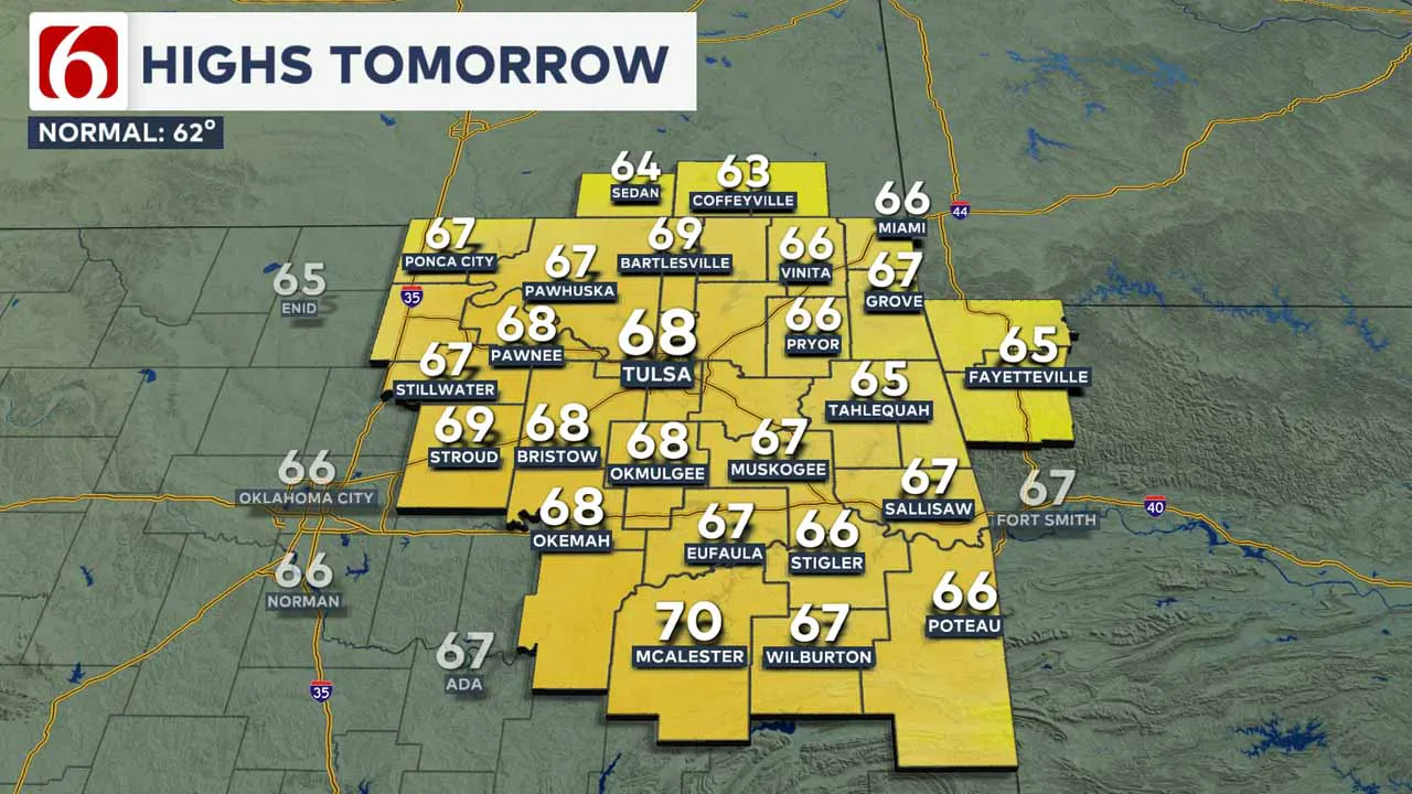
Thursday morning starts with a mixture of upper 30s and lower 40s and daytime highs in the mid-60s. Winds will be variable in direction and light and speed Thursday with sunshine and highs in the mid to upper 60s.

There's a low-end possibility of a few valley locations experiencing some patchy frost both Thursday morning and Friday morning.
After a chilly start Friday morning into the upper and mid-30s, daytime highs will reach in the upper 60s near 70 with sunshine and south winds at 10 to 15 mph.
The first round of the Oklahoma high school football playoffs will begin Friday. Game time Temperatures will start in the upper 50s and drop into the lower 50s with clear sky and light south winds.
A strong upper-level system is developing this weekend to our west. This will cause surface pressures to fall and gusty south winds returning at 15 to 25 mph.
Saturday morning lows will be in the mid-40s and afternoon highs near 70 with sunshine and a few clouds. As the powerful upper-level system draws closer to the area, more clouds will be likely on Sunday with gusty south winds and highs in the upper 60s and lower 70s.

From Sunday night into Monday, the strong upper-level system ejects across portions of northern Oklahoma into central Kansas.
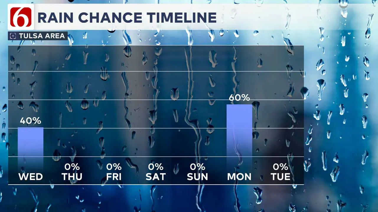
This is a dynamic storm system. Showers and storms will be likely Monday, including the possibility of some locally heavy rainfall. If enough deep, low-level moisture arrives ahead of the system, severe weather threats will return Monday based on the strength of the upper-level system.
As this storm rapidly ejects away from the area Monday afternoon, much cooler weather will arrive behind the frontal boundary.
Consequently, a strong upper-level low will develop across the Midwestern US and bring much colder weather to the northeastern part of the nation.
Most ensemble data bring some colder weather across Oklahoma by the middle to the end of next week. Stay tuned for more on these different scenarios.
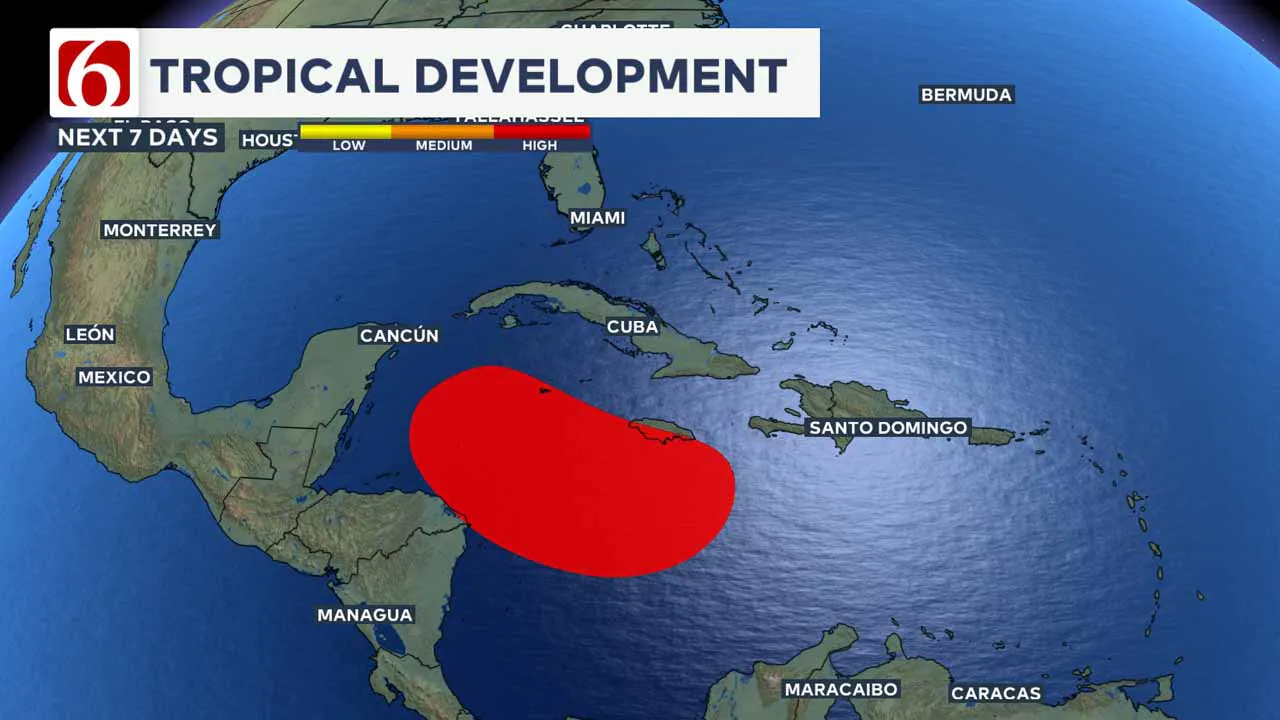
Forecasters at the National Hurricane Center are monitoring a developing system in the southern Caribbean. The pattern is favorable for this system to blossom into a named storm and possibly emerge into the Gulf of Mexico next week.

---
Emergency Info: Outages Across Oklahoma:
Northeast Oklahoma has various power companies and electric cooperatives, many of which have overlapping areas of coverage. Below is a link to various outage maps.
Indian Electric Cooperative (IEC) Outage Map
Oklahoma Association of Electric Cooperatives Outage Map — (Note Several Smaller Co-ops Included)
The Alan Crone morning weather podcast link from Spotify:
https://open.spotify.com/show/0dCHRWMFjs4fEPKLqTLjvy
The Alan Crone morning weather podcast link from Apple:
Follow the News On 6 Meteorologists on Facebook!

More Like This
November 13th, 2024
November 13th, 2024
November 13th, 2024
November 13th, 2024
Top Headlines
November 13th, 2024
November 13th, 2024
November 13th, 2024
November 13th, 2024


