Christmas Day Forecast: Be Ready For Blizzard Conditions
Widespread snow is likely across the state and higher snowfall totals are looking more and more probable.Sunday, December 23rd 2012, 7:54 pm
Here's the latest on the winter storm headed for Oklahoma on Christmas Day:
Widespread snow is likely across the state and higher snowfall totals are looking more and more probable. Blowing snow will be an issue and could result in complete whiteout conditions at times. This means the potential for major statewide travel disruptions on Christmas Day.
A wintry mix is expected late Monday night in northwest Oklahoma. This will quickly transition to snow and move across the main body of the state Christmas Day. Snowfall amounts will likely change as the exact track of the storm becomes more apparent. As of now, expect 1-2 inches of snow for areas in light blue, 2-4 inches for areas in purple and 6-8 inches with localized higher amounts for areas in pink. Snowfall will come to an end by early Wednesday morning.
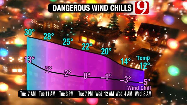
Temperatures will also be a major issue with this storm. Arctic air will rush in Christmas Day, dropping temperatures from the 30s early in the morning to the teens Christmas night. Fierce north winds will make for dangerous wind chill values in the teens most of Tuesday and eventually below zero by Wednesday morning.
Stay with News 9, we'll keep you advised.
More Like This
December 23rd, 2012
November 13th, 2024
October 28th, 2024
October 17th, 2024
Top Headlines
December 26th, 2024
December 26th, 2024
December 26th, 2024
December 26th, 2024


