Tracking A Winter Storm And Arctic Air
Oklahoma Weather Forecast: Bookmark this page and refresh it often for the latest forecast and daily updates.Friday, January 3rd 2025, 12:57 pm
TULSA, Okla. -
A major winter storm will impact the Southern and Central Plains states, extending through the Ohio and Middle Tennessee valleys this weekend. Arctic air will plunge southward, moving across Oklahoma early Sunday morning.
Light snow showers are possible, mainly across northern Oklahoma and into southern Kansas. Some measurable snowfall may occur along the state line region northward into southern Kansas.
Any snow in the Tulsa metro area is currently expected to be insignificant.
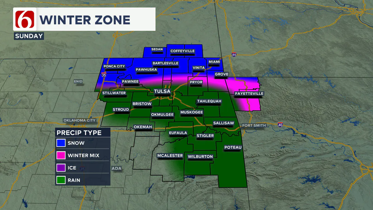
What’s the Major Impact For Most of Oklahoma?
The more significant and widespread issue will be the arrival of very cold weather, continuing for several days next week. Sunday morning temperatures across eastern Oklahoma will range from the 40s to the 50s before falling below freezing by midday.
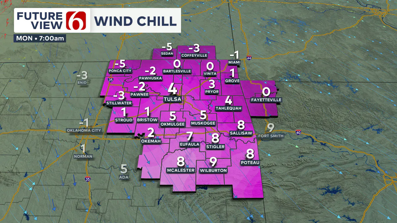
By late Sunday afternoon, most locations across the northern third of the state will be in the mid-20s. North winds at 20 to 40 mph will accompany this system, bringing plummeting wind chill values Sunday afternoon into Monday morning.
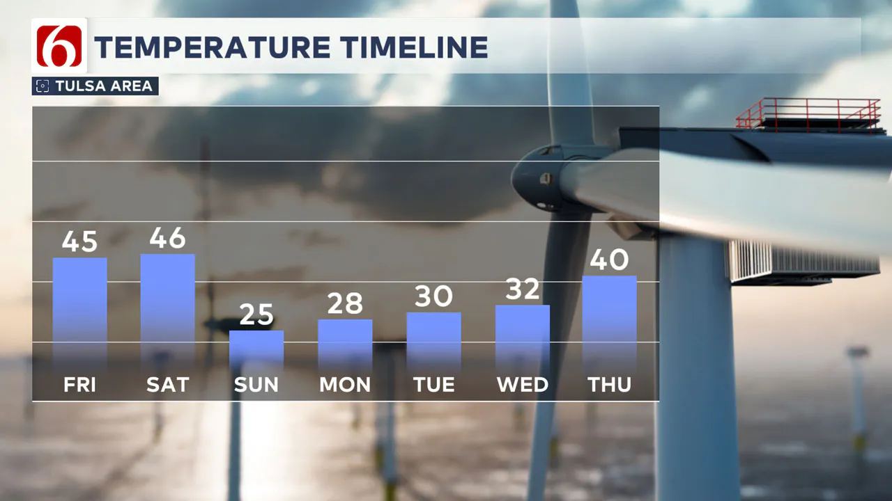
As the cold air becomes entrenched, sub-freezing temperatures are likely from Monday through at least Wednesday. By Thursday, the pattern should change, bringing daytime highs into the upper 30s and lower 40s.
Tracking Another Wave Nearby Late Next Week
In addition to Sunday's strong winter system, at least two additional disturbances will be near or south of the area from the middle to the end of next week. Snowfall potential will occur across Texas with both systems.
The first will arrive across southwest Texas Tuesday night and Wednesday morning, and the second, stronger system will arrive Thursday night into Friday across central Texas. This wave could produce some wintry precipitation impacting parts of southern Oklahoma.
Any additional northward shift in this wave could bring snow across a larger part of Oklahoma in the latter half of next week.
Today's Weather Overview
High temperatures today are expected to be in the lower to mid-40s across far northern Oklahoma and in the upper 40s near 50 across the southeastern third of the state.
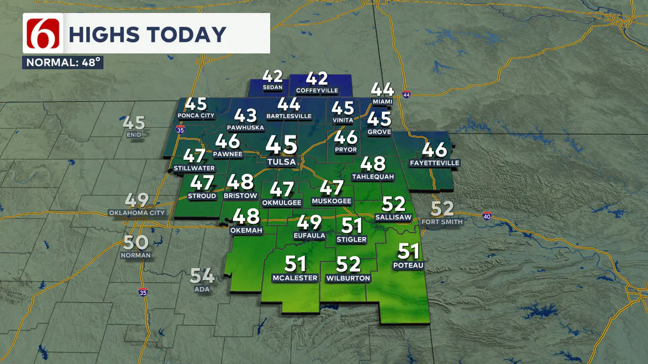
A mix of clouds is likely, including the potential for some low clouds through the early to middle part of the morning. North winds will remain at 7 to 12 mph.
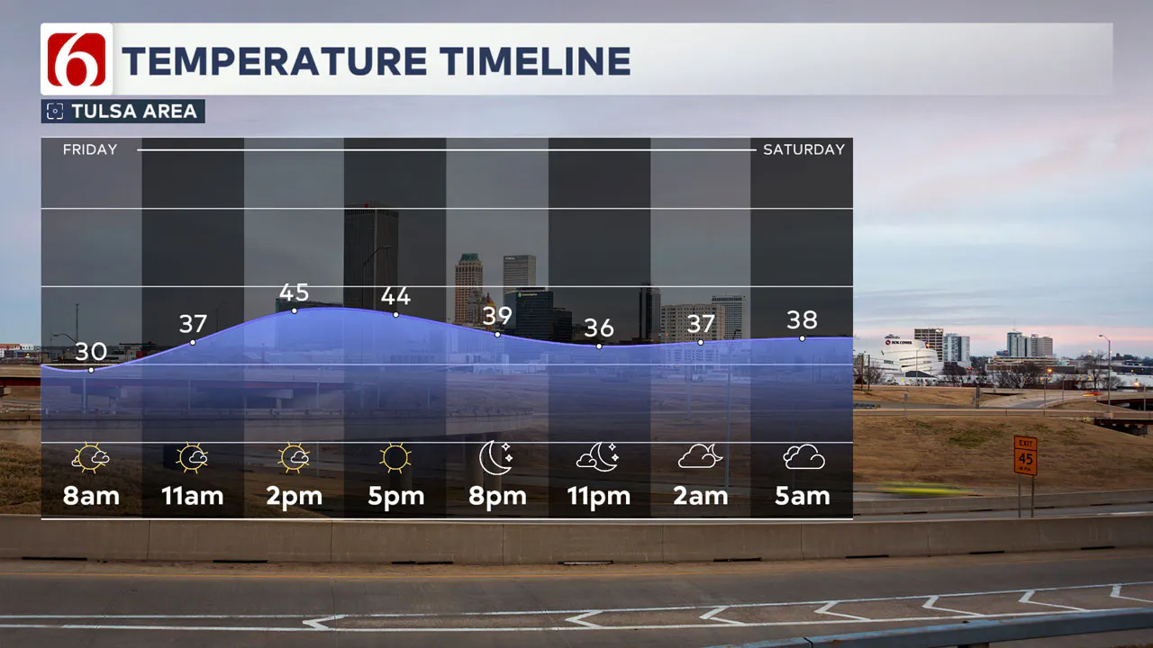
Saturday Weather Forecast
Saturday morning temperatures may briefly start near freezing but should rise to the mid-40s by early afternoon with south winds at 10 to 25 mph.
As the major system approaches, pockets of drizzle will develop on Saturday afternoon and evening. The threat of some freezing drizzle will exist across far southern Kansas by midday Saturday but should remain well north of most of our area.
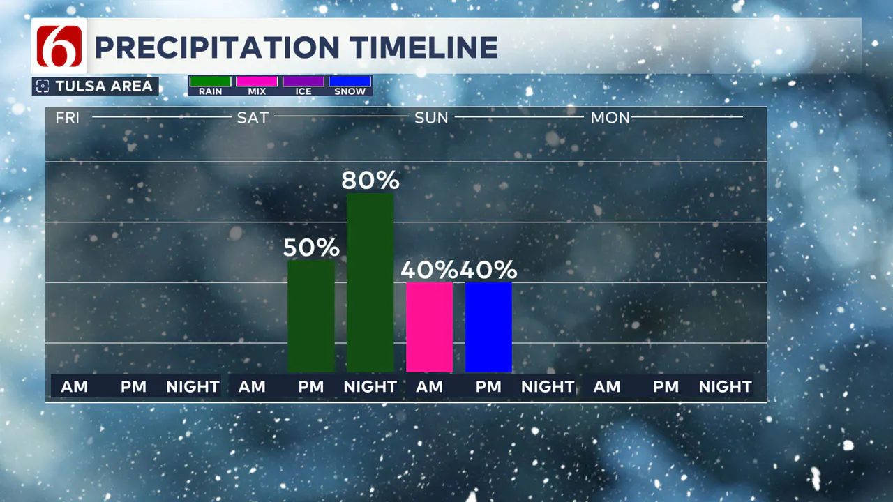
By Saturday night and early Sunday morning, the upper-level low will draw closer to the region, and a strong surface low-pressure area will develop across northwestern Oklahoma.
As this low moves mostly eastward, showers will develop near and east of the feature through Sunday morning. Temperatures will climb into the upper 40s and lower 50s.
Temperatures Plummet Sunday
As the low moves eastward, colder air will filter in behind the system, with plummeting temperatures and strong north winds of 20 to 40 mph. Some precipitation may flip over to light snow across far northern Oklahoma and into parts of southern Kansas.
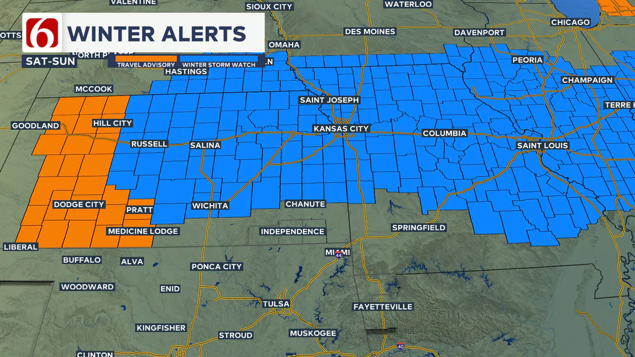
Slightly north of the Kansas state line region, more significant wintry weather impacts are likely. Winter storm watches and winter weather advisories are already posted for portions of Kansas along both sides of the I-70 corridor, extending well eastward into portions of Missouri, Kentucky, and Tennessee.
The threat of wintry precipitation will end by early Sunday afternoon, but colder weather will continue.
How Long Will the Deep Freeze Last?
Monday morning temperatures will start in the middle teens, but wind chill values will be in the single digits. Sunshine is likely Monday with north winds at 7 to 12 mph. Afternoon temperatures will remain in the upper 20s. Tuesday morning will start in the lower and middle teens.
Emergency Info: Outages Across Oklahoma:
Northeast Oklahoma has various power companies and electric cooperatives, many of which have overlapping areas of coverage. Below is a link to various outage maps.
Indian Electric Cooperative (IEC) Outage Map
Oklahoma Association of Electric Cooperatives Outage Map — (Note Several Smaller Co-ops Included)
The Alan Crone morning weather podcast link from Spotify:
https://open.spotify.com/show/0dCHRWMFjs4fEPKLqTLjvy
The Alan Crone morning weather podcast link from Apple:
Follow the News On 6 Meteorologists on Facebook!

More Like This
January 3rd, 2025
January 3rd, 2025
January 3rd, 2025
Top Headlines
January 3rd, 2025
January 3rd, 2025


