Above normal before the Arctic invasion this weekend
Oklahoma Weather Forecast: Bookmark this page and refresh it often for the latest forecast and daily updates.Thursday, January 16th 2025, 6:24 am
TULSA, Okla. -
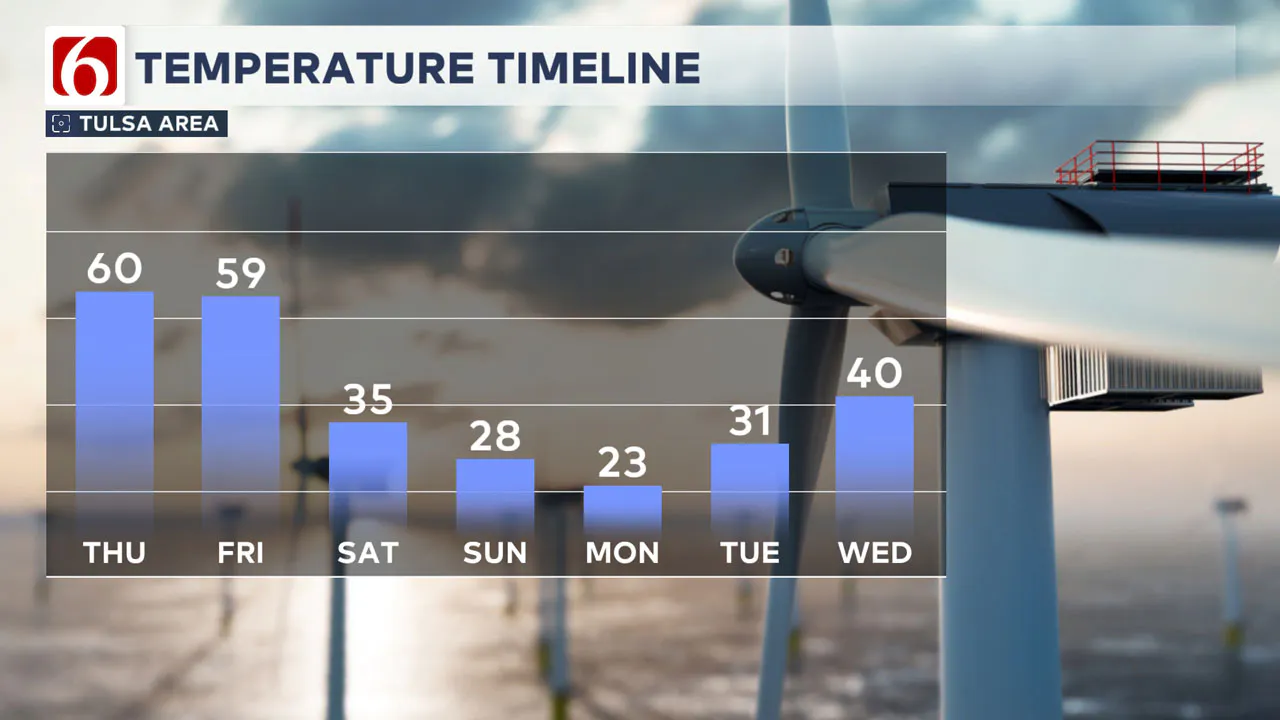
A warming trend is likely today and tomorrow ahead of a strong Arctic front that will roll across the area Friday afternoon and evening.
This will bring much colder weather on Saturday. A reinforcing shot of even colder air will arrive Saturday afternoon, plummeting temperatures below freezing through the early to middle part of next week.
Any Rain or Snow?
A few spotty showers are possible across extreme eastern Oklahoma Friday afternoon and evening ahead of the main boundary. This probability remains near or less than 20% for most of the area.
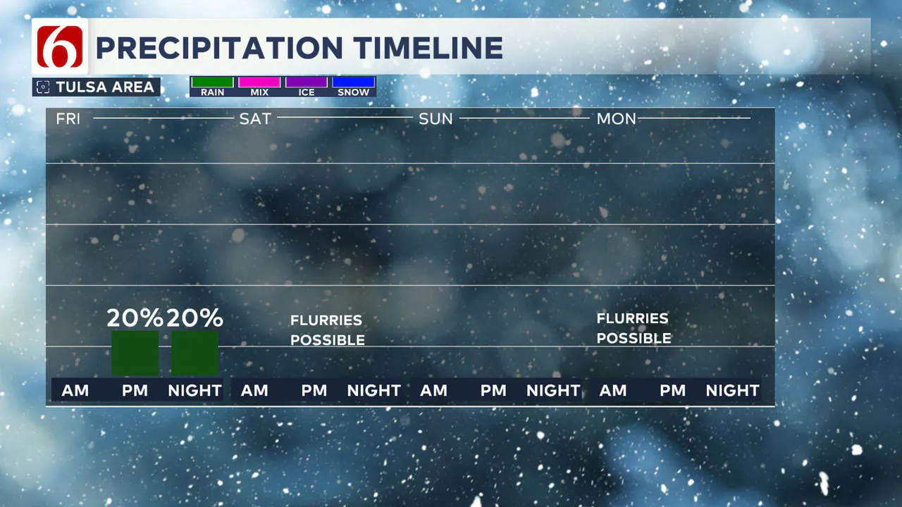
As much colder air filters across the central and Southern Plains states, there will be a slight chance for a few light snow showers late Saturday night and early Sunday morning.
The probability for measurable precipitation Saturday into Sunday remains near or less than 10%.
Watching A Texas Storm Early Next Week
A developing southern stream system is increasing for early next week, which may bring some snow potential across at least southern Oklahoma Monday night and Tuesday. However, most data suggest this system will stay mostly south of the Red River Valley.
Any northward change in the track would bring higher probabilities for snow across parts of the area on Tuesday. Another system may develop by the middle to the end of next week that could also bring some precipitation nearby.
What About Today?
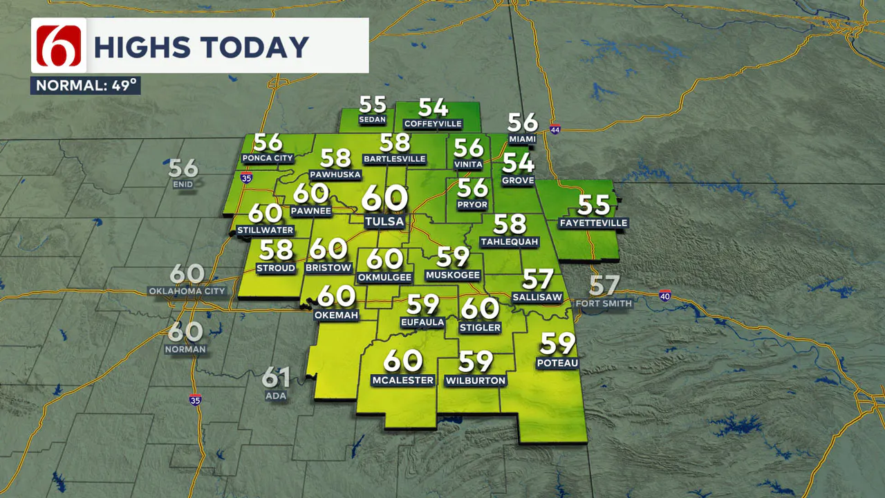
After starting this morning in the 20s and 30s, highs this afternoon will reach the upper 50s and lower 60s from Tulsa southward.
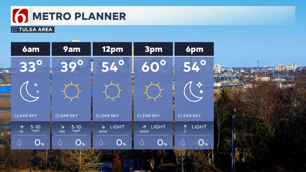
Some locations along the state line region into southern Kansas will remain in the mid-50s. Abundant sunshine is expected with a west-to-southwest wind at 10 mph.
Pressure gradients will increase overnight, bringing gusty south winds Friday at 15 to 25 mph. Morning lows will start in the 30s, with highs reaching the upper 50s near 60.
When Will the Arctic Front Arrive?
The leading edge of the shallow Arctic air will arrive by midday and early afternoon with strong north winds and falling temperatures.
A surface area of low pressure is expected along the boundary as it develops and may produce a few spotty showers, mostly across extreme eastern Oklahoma and western Arkansas.
This probability also remains near or less than 10%, with a 30% probability along the Oklahoma and Arkansas state line region.
Cold and Windy Weekend
Behind the front, strong north winds will develop at 15 to 30 mph. This will continue through the first part of Saturday with morning lows near 30. Saturday afternoon temperatures will be in the mid to upper 30s.
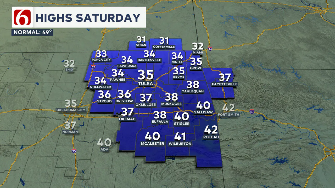
A second surge of much colder weather will arrive Saturday afternoon, knocking temperatures below freezing. Behind this second surge, an upper-level wave approaching from the northwest may produce some very light snow showers across parts of northern Oklahoma and southern Kansas.
The trajectory of this system could spread some light snow showers along and north of the I-40 corridor. The probability for measurable precipitation also remains near or less than 10%.
Martin Luther King Day Forecast
Martin Luther King Day will start with morning lows near 9 and daytime highs in the mid-20s. North winds at 10 to 15 mph will create wind chill values near or slightly below zero.
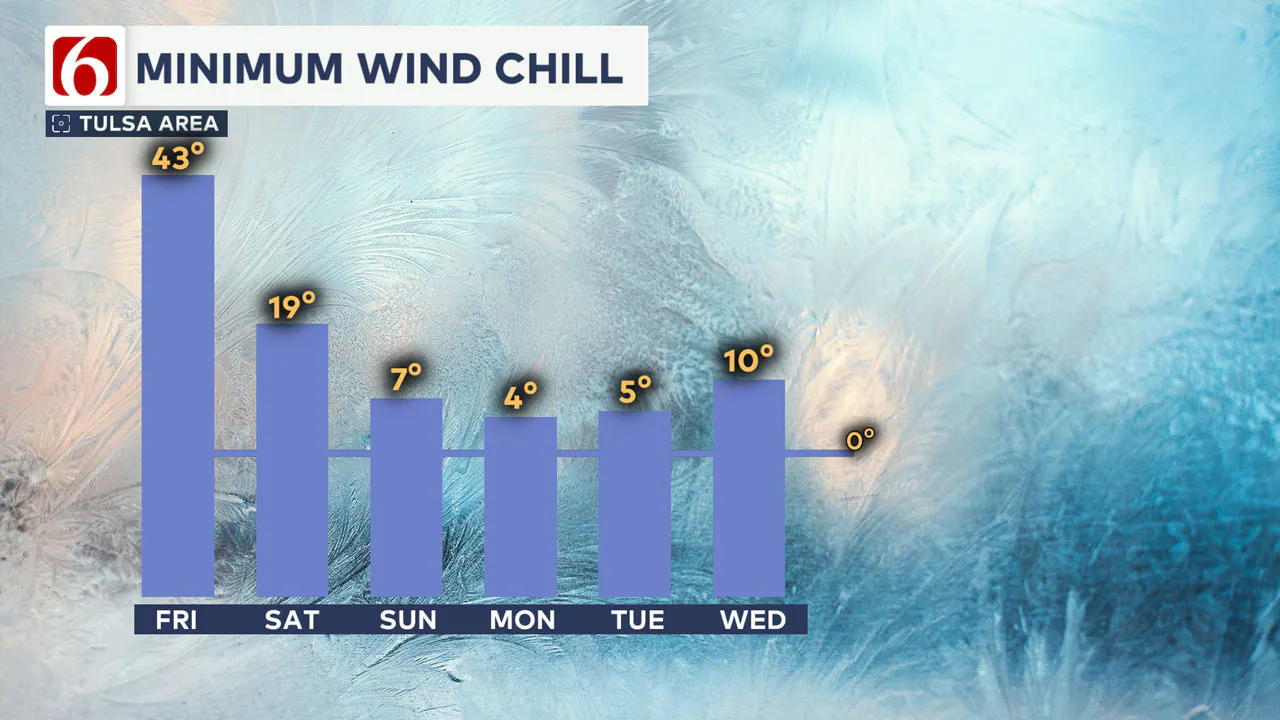
Snow will likely fall Monday across portions of eastern Colorado, the High Plains of Texas, and parts of western Oklahoma. Some light snow showers will be possible near or west of our area on Monday.
The probability for measurable precipitation remains near or less than 10%.
Anything to watch for next week?
A much stronger system is expected Tuesday across Texas. A consensus of data keeps the majority of this system near or south of the Red River, especially across East Texas into portions of the Ark-La-Tex region.
Some outlier model solutions suggest forcing will remain slightly more to the north and could bring measurable snow across parts of Oklahoma on Tuesday. Colder air will remain in place with morning lows in the teens and daytime highs in the 20s.
This portion of the forecast regarding precipitation chances will likely undergo some changes between now and next week, so please stay updated.
>>> How To Prepare Your Car For Oklahoma Winter Weather
Where are the warming shelters available in Tulsa this year?
The city of Tulsa, local shelters, warming stations, and outreach teams are working to ensure access to safe, warm spaces during the cold temperatures.
>>> Warming Shelters Open Across Tulsa Amid Freezing Temperatures
Tulsa shelters and temporary warming locations are open to provide refuge. Major locations include:
- John 3:16 Mission, 506 N. Cheyenne — Open 24/7
- The Salvation Army Center of Hope, 102 N. Denver Ave. — Open 24/7
- Tulsa Day Center, 415 W. Archer St. — Open 24/7
Temporary overflow shelters will also be open for the cold weather:
- Tulsa Dream Center, 4122 W. 55th Pl. — Opens Sunday, Jan. 5, at 3 p.m. and closes Tuesday, Jan. 7, at 9 a.m.; Adults only, pet-friendly.
- Rose Bowl, 7419 E. 11th St. — Opens Sunday, Jan. 5, at 2 p.m. and closes Thursday, Jan. 9, at 9 a.m.; Adults only.
For a full list of warming station locations and hours, visit Housing Solutions’ Winter Weather Information Page.
>>> Warming Shelters, Safety Tips For Cold Temperatures This Winter In Oklahoma
Bring Pets Inside!
Winter temperatures can pose additional challenges for pets, particularly older animals or those with health conditions. Hartfield recommends:
- Wellness Checks: Ensure pets are up to date on vaccines and discuss arthritis or other cold-weather health concerns with a veterinarian.
- Outdoor Time: Monitor the duration of outdoor activities, especially for short-haired breeds or pets with conditions like diabetes or heart disease.
- Paw Care: After walks, inspect and clean paws to remove ice or de-icing chemicals that could harm your pet.
>>> Cold Weather Pet Tips: How To Keep Animals Safe During Winter Months
How Can I Protect Myself From Sickness This Winter?
The Tulsa Health Department is urging residents to receive flu and COVID-19 vaccinations to prevent respiratory illnesses as Oklahoma enters the coldest months of the year.
- Health experts say the risk of respiratory illnesses is higher during the winter, as colder weather often leads to more indoor gatherings, increasing the likelihood of viruses spreading.
- The Centers for Disease Control and Prevention says Oklahoma is one of 11 states with very high respiratory virus activity, and with flu vaccination rates lower than this time in 2024, more people have reported getting sick.
>>> How to Protect Yourself From Respiratory Illness This Winter
Emergency Info: Outages Across Oklahoma:
Northeast Oklahoma has various power companies and electric cooperatives, many of which have overlapping areas of coverage. Below is a link to various outage maps.
>>> Tulsa HVAC, Plumbing Companies Flooded With Calls During Cold Weather
- PSO Outage Map
- OG&E Outage Map
- VVEC Outage Map
- Indian Electric Cooperative (IEC) Outage Map
- Oklahoma Association of Electric Cooperatives Outage Map — (Note Several Smaller Co-ops Included)
The Alan Crone morning weather podcast link from Spotify:
https://open.spotify.com/episode/0xiaGO0qPsWNoVH3Ai9MOC
The Alan Crone morning weather podcast link from Apple:
Follow the News On 6 Meteorologists on Facebook!
- Meteorologist Travis Meyer
- Meteorologist Stacia Knight
- Meteorologist Alan Crone
- Meteorologist Stephen Nehrenz
- Meteorologist Aaron Reeves
- Meteorologist Megan Gold

More Like This
January 16th, 2025
January 16th, 2025
January 16th, 2025
January 16th, 2025
Top Headlines
January 16th, 2025
January 16th, 2025
January 16th, 2025
January 16th, 2025


