OKC Winter Storm: Day 2 of below-freezing conditions
We enter Day 2 of record-breaking lows, dangerous wind chills and hazardous road conditions. Meteorologist Lacey Swope has the latest forecast.Wednesday, February 19th 2025, 8:08 am
OKLAHOMA CITY -
A significant winter storm has made its way into Oklahoma, bringing a combination of freezing rain, sleet, and snow.
MORE COVERAGE: Snowstorm in OKC: Here’s a look at Tuesday’s storm impacts
The forecast warns of serious risks like hypothermia and frostbite for anyone caught unprepared, so be sure to bundle up if you plan to be outside.
While the snowfall has tapered off, dangerous travel conditions and extreme wind chills will persist into Wednesday morning.
RELATED: OKC highway traffic slows as drivers face frozen roadways
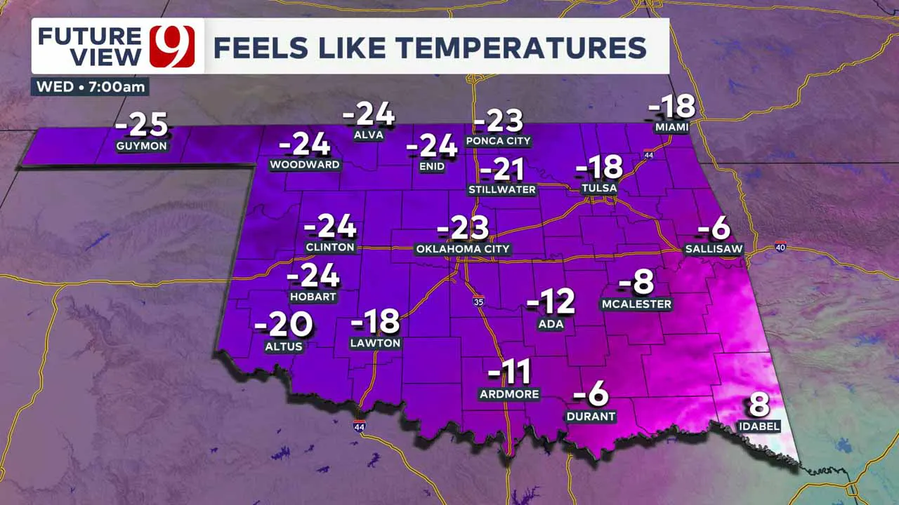
Temps on Wednesday start off in the single digits, with wind chills pushing the feel-like temperature well below zero degrees.

Icy Roads and Lingering Hazards
Road conditions remain hazardous across much of Oklahoma, particularly in northern and central areas. Highways and city streets are still covered in ice and snow, making travel dangerous.
Marty Logan, reporting from northwestern Oklahoma, described roads in Woodward County as “a sheet of ice,” with temperatures as low as 5 degrees. In Oklahoma City, roads remain slick, with some areas seeing more than an inch of snow accumulation.
Officials advise against unnecessary travel, especially on interstates such as I-40 and I-44, where icy patches have caused accidents and delays.
Extreme Cold and Dangerous Wind Chills
Temperatures remain in the single digits across much of the state, with wind chills making it feel even colder:
- Oklahoma City: 10 degrees, with wind chills as low as -10
- Enid: 5 degrees
- Woodward: 4 degrees
- Ponca City: 6 degrees
Strong north winds between 10-20 mph, with gusts up to 30 mph, will keep wind chills dangerously low overnight. Some areas may experience wind chills between -20 and -30 degrees.
A Gradual Warm-Up Ahead
Relief is on the horizon, as temperatures are expected to slowly climb in the coming days. Wednesday will still be frigid, with highs struggling to reach double digits in northern Oklahoma. However, by the weekend, highs will rebound into the 40s, with 60s possible by early next week.
Officials urge residents to limit time outdoors, dress in layers, and check on vulnerable neighbors and pets as the extreme cold persists. Travelers should continue to use caution on the roads as icy conditions are expected to last into Wednesday morning.
Winter precipitation totals
Totals will range from 1-3 inches across the Oklahoma City metro, with most on the north side.
If we see more sleet, precipitation totals could be less.
There will be some folks in the northern part of the state who could see 4-7 inches, and possibly up to 10 inches. Drifts up north could be measured in feet.
How cold will it get?
Dangerous temperatures begin on Tuesday. We will likely shatter record lows and record cold highs.
We will likely stay below freezing from Tuesday morning until Saturday, over 100 total hours.
This could mean a pipe-bursting scenario for many residents, especially with highs in the single digits and low teens.
Wind chills will be brutal. Frostbite and hypothermia are a concern with wind chills down to 25 below zero.
SEE ALSO: Oklahoma health experts warn of frostbite as temps drop below freezing
Our team of trackers will be out for you and we will bring you live updates. Stay safe and warm!
What to Expect
- Tuesday: A winter storm will sweep through, bringing a wintry mix before transitioning to snow across much of the state.
- Accumulation: Several inches of snow are possible in northern Oklahoma, with central areas, including OKC, on the edge of heavier snowfall.
- Extreme Cold: Temperatures will plummet into the single digits by Wednesday, with wind chills as low as -30°F in some areas.
- Dangerous Conditions: “This is a multi-day record cold event,” Adams said. “Expect below-zero mornings and brutally cold afternoons.”
Prepare for the Arctic Blast 🥶
- Roads: Slick spots are likely, especially early in the week. Drive carefully!
- Pipes: Protect pipes from freezing by dripping faucets and insulating exposed lines.
- Pets & People: Limit time outdoors. Frostbite can set in within minutes in these conditions.
The worst of the cold will last through Friday morning before temperatures slowly rebound over the weekend. Stay with News 9 for the latest weather updates.
📉 Timeline & Temperatures
- Tuesday-Thursday:
- Heavy snow is possible from I-40 north
- Freezing rain & sleet in central Oklahoma
- Rain transitioning to ice & snow in the south
- Wind chills between -15°F to -30°F 🥶
- Wednesday: Forecasted high of just 9°F—potentially a record-breaking cold day.
🌨️ Snowfall & Ice Impacts
- Up to 1 inch of snow is expected in OKC Saturday night.
- More than 5 inches are possible in northern Oklahoma on Tuesday.
- Treacherous road conditions, power outages, and school closures are likely.
WINTER WEATHER PREP:
- 3 Ways To Save Money On Energy Bills During The Winter
- Q&A With OKC Fire Captain On Ways Homeowners Can Prevent, Prepare For Winter Fires
- OG&E Shares Winter Readiness And Power Outage Tips
- Space Heater Safety Tips For The Winter Season
- Tips On How To Beat Seasonal Affective Disorder And The Winter Blues
----
Follow our meteorologists!
More Like This
February 19th, 2025
February 19th, 2025
February 19th, 2025
Top Headlines
February 19th, 2025
February 19th, 2025
February 19th, 2025


