Winter Storm Timeline: What To Expect On Thursday And Friday
Meteorologist Lacey Swope breaks down the latest on Thursday’s winter storm, including what to expect for snow totals, road impacts, and timing.Friday, January 10th 2025, 10:23 am
As a winter storm approaches Oklahoma, our team of Meteorologists is here to guide you through what to expect.
Latest Warnings:
- Winter Storm Warning For Ellis, Woodward, Major Roger Mills and Dewey County until 8 a.m. Friday
From potential snow totals to the timing of icy conditions and road impacts, we are breaking down everything you need to know to stay safe and prepared.
Here is the latest timeline:
Thursday Morning (6 AM - 12 PM):
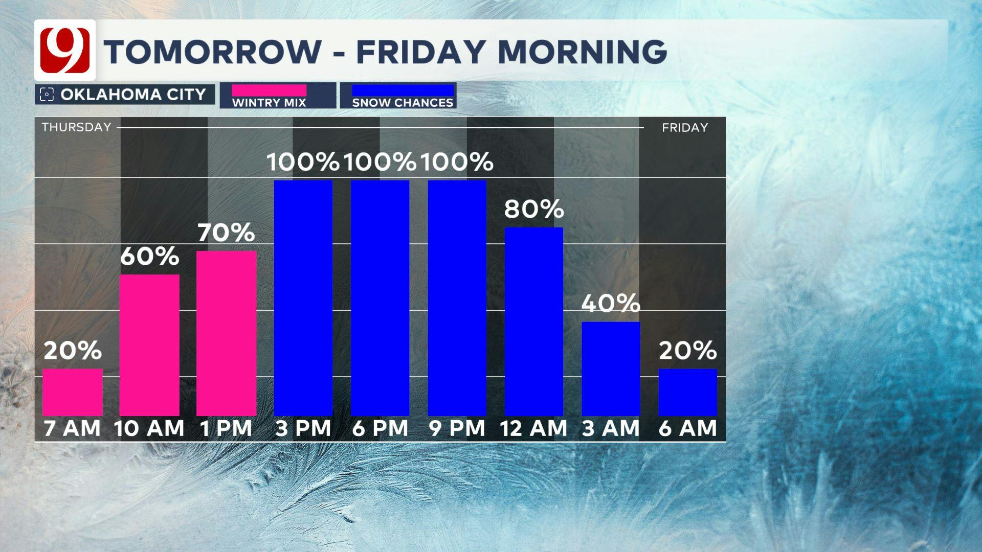
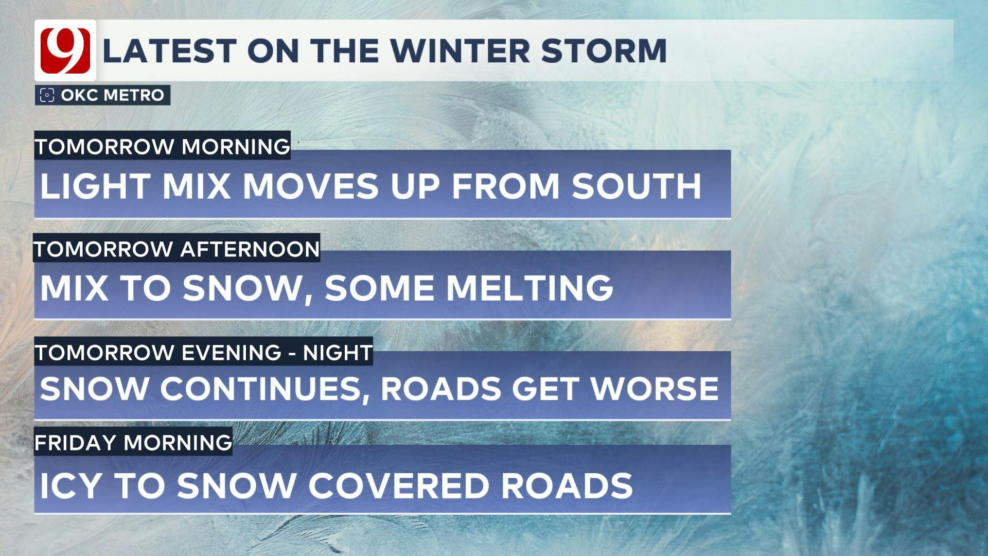
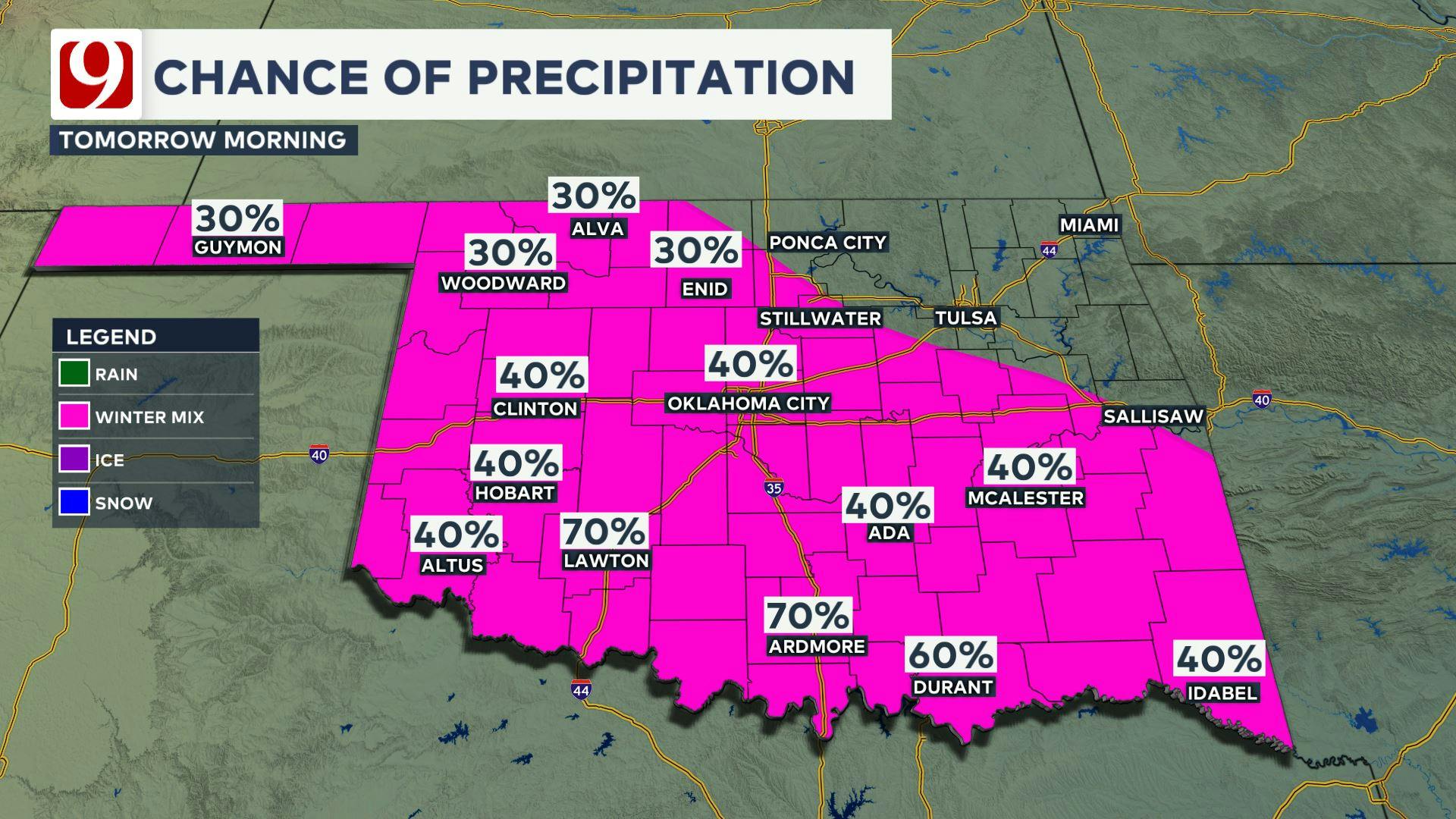
- Weather: Precipitation begins, starting as a mix of rain, sleet, and light snow. Temperatures hover near freezing (32°F), causing some initial melting.
- Impact: Slick spots on untreated roads. Visibility may be reduced during periods of mixed precipitation.
LIVE UPDATES:
6:11 AM: Sleet and light snow are hitting the metro. There are no major effects yet; News 9 trackers are out monitoring conditions.
6:39 AM: On and off sleet is falling in downtown Oklahoma City with no major effects.
7:30 AM: Flurries reported in Blanchard.
8:00 AM: Snow hitting El Reno.
8:30 AM: Jeromy Carter is tracking snowy roads in and around Chickasha.
9:00 AM: It is snowing in Downtown Oklahoma City.
10:00 AM: Roads are beginning to have slick spots. Many counties in Oklahoma are blanketed with snow.
10:13 AM: Trackers are out, roads and highways are slick. Trackers are reporting cars on the side of the road on I-40 in Midwest City.
10:23 AM: Snow and slick spots are causing delays near the Tinker Diagonal.
10:34 AM: ODOT crews are clearing/treating major roads and highways.
10:36 AM: Jeromy Carter shows icy roads along I-35 in Murray County.
10:52 AM: American Airlines canceled all flights from DFW to OKC.
11:39 AM: Tom Pastrano is showing heavy snow in Norman. The University of Oklahoma campus is blanketed in snow.
11:46 AM: News 9's Jennifer Pierce reports several inches on the ground in downtown Norman but said roads have not been greatly affected.
11:50 AM: Jeromy Carter reports six to seven inches of snow in Wynnewood.
11:56 AM: News 9's Deanne Stein reports a layer of light, packable snow in Yukon.
Thursday Afternoon (12 PM - 6 PM):
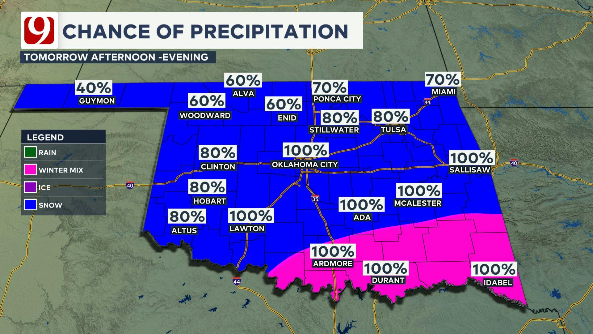
- Weather: Precipitation transitions to mainly wet snow across central Oklahoma. Heaviest snow expected southeast of I-44. Temperatures are just above freezing until 5:00 PM. After 5, temperatures drop and eventually reach the upper 20s.
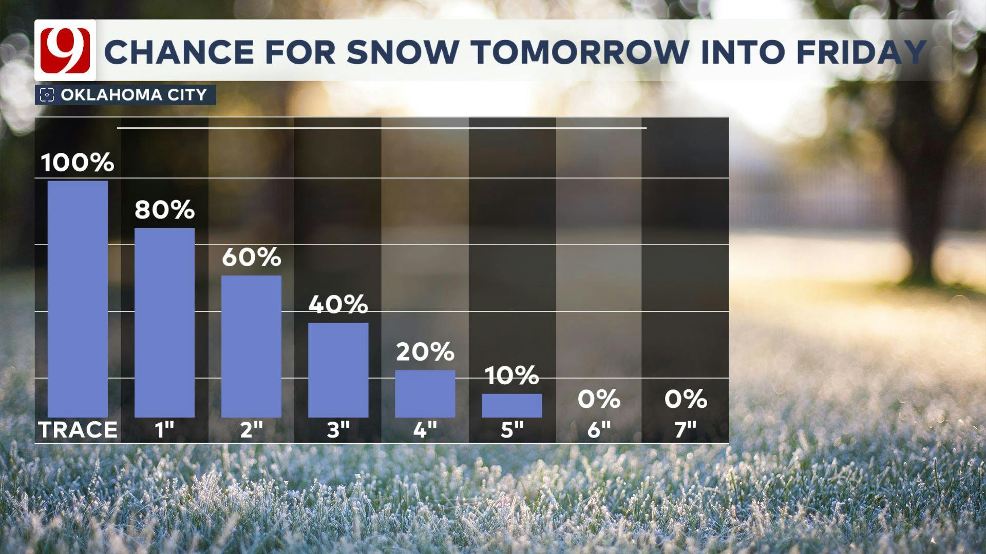
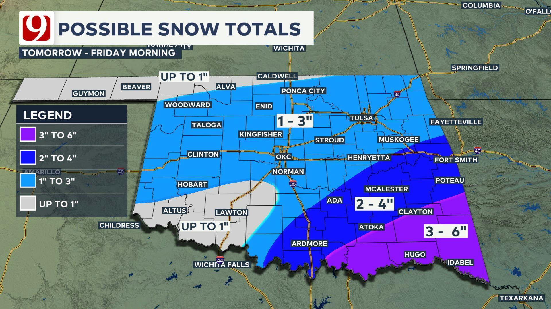
- Impact: Slushy road conditions are likely, with accumulating snow in grassy areas and elevated surfaces. After 5:00 PM, roads get worse. Slush could turn to ice, and some roads become snow covered. Snowfall totals range from a trace to 3 inches in the metro and higher amounts (3-6 inches) southeast of I-44.
LIVE UPDATES:
12:14 PM: Secondary/side roads still covered in snow and icy conditions.
12:15 PM: News 9's Tevis Hillis reports citizens in trucks helping to pull a car out of a ditch off Interstate 40 near Shawnee.
1:00 PM: Snow continues to fall across the state. Roads are driveable in the Oklahoma City metro, but with extreme caution.
2:00 PM: Schools across the Oklahoma City metro have begun announcing closures or virtual days for Friday, Jan. 10. Check out News 9's full school closings list.
2:21 News 9's Jennifer Pierce reports from Norman, where snowfall is steady and roadways are cleared.
2:30 PM: News 9's Marty Logan in Woodward, where there are about 3 inches of snow and roads are slushy.
2:45 PM: EMSA said crews in Oklahoma City have responded to 2 cold exposure calls and 24 traffic accidents. EMSA urged residents to stay inside, but to dress in layers and only be outside for a short time if necessary.
2:45 PM: Oklahoma Governor Kevin Stitt said these state agencies are working to respond to winter weather: the Oklahoma National Guard (OKNG), Oklahoma Department of Public Safety (DPS), Oklahoma Turnpike Authority (OTA), Department of Transportation (ODOT), and Oklahoma Department of Emergency Management (OEM.)
3:22 PM Tom Pastrano is in Purcell, where crews work to clear main streets. There are about 4 inches of snow on the ground, and snowfall is continuing.
3:30 PM: All lanes of southbound I-35 are now open near US-77 in Davis following an earlier crash.
4:30 News 9's Elizabeth Fitz reports from Scissortail Park, where a crowd is gearing up for a snowball fight
Thursday Evening (6 PM - 12 AM):
- Weather: Snow continues into the evening hours, tapering off overnight. Temperatures remain below freezing.
- Impact: Any moisture on roads freezes, and snow sticks. Icy and snow-covered roads may lead to hazardous driving conditions. Potential for very slick roads and delays.
LIVE UPDATES
6:00 PM: The city of OKC sends out a newsletter saying:
- They have 32 trucks out, working 12-hour shifts around the clock
- No trash collection on Friday
- Municipal court closed Friday
- OKC police are not responding to non-injury crashes
7:00 PM: Oklahoma City officially beats the record snowfall for the day set in 1977.
9:00 PM: News 9's Jeromy Carter is on I-40 in southwest Oklahoma City. He says ODOT is treating the roads but it is best to use precaution when driving.
Friday Morning:
- Weather: Snow ends early, and skies begin clearing. Morning lows dip into the low 20s, with wind chills in the teens.
- Impact: Expect icy patches on roads and sidewalks. Many roads will be snow-covered. Drivers should exercise caution during the morning commute.
Our team of storm trackers will be out for you. Roads will improve throughout the day.
LIVE UPDATES:
6:00 AM: News trackers report snow-covered roads in Moore neighborhoods.
6:08 AM: Reporters show Grand Boulevard onto I-44, mostly clear of snow but with a few lingering slick spots.
6:14 AM: Brandon Pennel shows that the outside lanes of I-35 in Norman are still covered with a layer of snow. Traffic is moving slower.
6:15 AM: Hank Brown reports roads in southeast Oklahoma City are still snow-packed and have slick spots.
6:17 AM: I-40 eastbound is being shut down at mile marker 247 in McIntosh County due to several semis stuck in the roadway.
6:20 AM: ODOT says to use much caution when traveling this morning. Bridges and overpasses are very slick.
6:25 AM: Val and Amy Castor report snow and ice-covered roads in Edmond neighborhoods.
6:33 AM: Jeromy Carter reports that Wayne roads are plowed but slick.
7:00 AM: Trackers report snow-covered side roads in Oklahoma City and Norman.
7:08 AM: Val Castor said interstate roads in OKC are mostly clear but very wet and cars and he has seen cars sliding. He said the Belle Isle Bridge is very slick, and drivers should exercise caution.
7:15 AM: Jeromy Carter said rural roads in Pauls Valley are snow-packed and crunchy.
7:38 AM: Trackers report 7 inches of snow in Wynnewood and 5 inches in east Norman.
7:40 AM: The sun is rising, expecting to help melt some snow and ice and help road conditions.
7:45 AM: News 9's Addie Crawford reports highways in the Oklahoma City area are less active than normal. Roads are mostly clear but she has seen cars sliding when making turns in intersections.
8:00 AM: News 9's Jennifer Pierce reports that salt trucks in Oklahoma City are still working to clear roads.
8:06 AM: I-40 in McIntosh County is back open.
8:20 AM: Traffic maps show slowdowns on Highway 9 near the Riverwind Casino.
8:26 AM: Val and Amy Castor report 1 to 3 inches of snow in Edmond. Roads are driveable but with caution.
8:27 AM: Marty Logan shows snow-packed and crunchy roads in Woodward.
8:45 AM: No significant accidents have been reported in the Oklahoma City metro.
8:50 AM: Traffic cameras show roads are beginning to clear in Guthrie.
9:06 AM: Jennifer Pierce shows traffic in Southwest Oklahoma City near the airport is moving like usual and most roads are clear.
9:18 AM: Marty Logan estimates 9 to 10 inches of snow in Fort Supply.
9:30 AM: Most main roads are wet as snow and ice continue to melt. Side roads still may have a sheet of ice.
Friday Afternoon:
- Weather: Sunshine returns, helping to melt snow and ice. Temperatures rise into the mid-30s.
- Impact: Conditions improve significantly, with less risk of icy roads. We may see some refreezing Friday evening into Saturday.
More Like This
January 10th, 2025
April 11th, 2025
April 11th, 2025
Top Headlines
April 11th, 2025


